Of all the things that Bosnia does (perhaps placing Yugo-nostalgia to one side for a minute), hiking is possibly what it does best. There are literally hundreds of hiking routes around Bosnia and Herzegovina, suited to a wide range of abilities and tastes.
There's even a mega trail (called Via Dinarica), promoted and developed by a platform with the same name, linking seven countries across the Dinaric Alps, from Albania to Slovenia, along what is called "The White Trail". This trail crosses over 1,200 km and covers the highest peaks of the Dinaric Alps, taking about three months to complete on foot.
You can book a tour with a company such as Green Visions, find a local guide, or go it alone, using one of the available online resources. Only go it alone if you know what you are doing, and, if you do go it alone, be aware that there are still a large number of landmines/fields in Bosnia and Herzegovina (many of which are marked): make sure to educate yourself on where they are (often close to former front-lines) and how to spot them. There are also two types of poisonous snake in Bosnia and Herzegovina, though death is rare. In terms of the weather, the best hiking months are generally from April until October, but you can do some snowshoeing in the colder months - just make sure you are equipped for what can be bitterly cold and quickly changing conditions. Similarly, lightening strikes can occur on the higher ridges in storms, so avoid being there at all in these conditions.
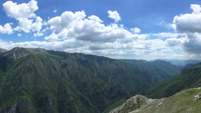
Trebević
The peak of Mt. Trebević
One of the great things about Sarajevo is how close it is to a huge range of hiking routes. Of all of them, none are closer than Mt. Trebević which is literally on the doorstep of the city, connected by a cable car which takes you to the hike start point (the more enthusiastic can walk all the way from the city- with the hike commencing at their front door).
Mt. Trebević could be described as an intermediate climb, taking just under six hours in total, taking you over about 16km of terrain, to a peak elevation of 1,629 metres. The views over the city and the valley are spectacular.
The start of the walk provides an opportunity to check out the old abandoned bobsled track and to stop of in the cafe at the Pino hotel for a cup of coffee before you start (there is also a mountain hut on the mountain where you can do the same). Mt. Trebević is one of the places with landmines, so stick to the trail and keep an eye open for markings.
Trebević details
Peak: 1,629 metres
Ascent: 811 metres
Distance: 16 kilometres
Duration: 6 hours
Located right on the edge of Sarajevo, with cable car access
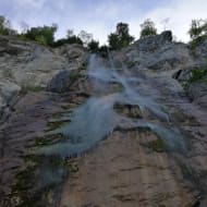
Skakavac is also right on Sarajevo's doorstep. Skakavac is the highest continually flowing water fall in the whole of Bosnia and Herzegovina: the top is 98 metres above the bottom.
The walk is not a challenging one and once you get to the waterfall there is a picnic site where you can rest, have snack, and take in the waterfall you walked all this way to see.
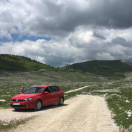
Lukomir perhaps the best example of a highland village with traditional architecture in Bosnia and Herzegovina. Lukomir is also the highest (1,469m), most isolated, permanent settlement in the country. More than this, the surrounding area is stunning.
Lukomir itself it technically a two hour drive from Sarajevo, but this is because the final stretch is unpaved (and inaccessible by car in winter) and adds about an hour to the journey. In any case, you will likely want to hike there and you can do this from a number of places just an hour from Sarajevo, such as Umoljani for example.
What's great about hiking in this location is there are so many options available to you. Just take a look at the Outdooractive trail options for Lukomir: there is a 32.5km trail climing up from Raktinica Canyon to the village; a 39.1 km trail from Lukomir to the top of Mount Ormanj (2,097m); a more relaxed 15.1 km trail between Umoljani and Lukomir; the list goes on.
Once you get to Lukomir, there is a moutain lodge there offering some Bosnian classics to help you refuel. Word of warning though: I got there quite late once and there was nothing left to eat.
Lukomir and Around details
Highland village
Located at 1,469 metres
Supposedly among the longest continually inhabited villages in all of Europe
Many differnent hike options available from and to Lukomir
Located just south west of Sarajevo with trails starting less than an hours drive from the city
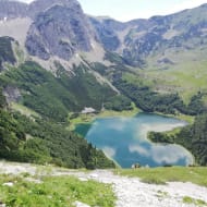
Maglić is not quite so close to Sarajevo, but it is Bosnia and Herzegovina's highest peak and offers some of the best hiking. There are many routes you can take and you can choose depending on your level. The hike up will take you through some of the oldest primaeval forest in Europe in Sutjeska National Park and then provide you with stunning views of the Dinaric Alps, as well as into Montenegro.
You can even stroll across and over into Montengro and hike down to Trnovačko lake, a heart shaped mountain lake. The hike linked below is quite a challenging one that you should probably have mountaineering boots for, but you can find others on the Outdooractive trail options for Maglić.
Maglić details
Bosnia and Herzegovina's highest peak
Peak: 2,386 metres
Duration: 6.5 hours
Distance: 12.6 kilmetres
Located about a two hour drive from Sarajevo on the border with Montenegro
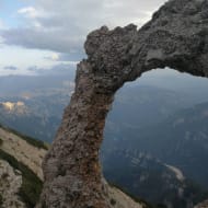
One of the most classic hikes to do here takes you up to a geological formation called Hajdučka vrata, which is a circular archway, high up on Čvrsnica mountain. The hike up Hajdučka vrata starts from the ski trail in Blidinje and takes about 6 hours.
Blidinje Nature Park and Hajdučka vrata details
Stunning geological formation in a beautiful nature park
Duration: 6 hours
Distance: 17 kilometres
Located just over a two hour drive from Satajevo to the south west
If you're into birds, this is an excellent bird reserve, the largest in southeast Europe, and recognised as a Ramsar site. The reserve is based around a sub-Mediterranean wetland around Deransko lake. Read more about Hutovo Blato nature park here.
If you like hiking, I assume you like being outdoors and moving forward by the means of your own muscles. This being true, you possibly also like cycling. Bosnia and Herzegovina has some amazing mountain biking trails. There's also a 100 mile paved bike trail (suitable for tourers and hyrbrids) from Mostar to Dubrovnik that follows the route of an old Austro-Hungarian rail track.